2006 CPGIS Young Scholar Workshop: Day 3

昨天第三天主讲人是地理所的岳天祥、北师大的陈晋以及Georgia Institute of Technology的Zhou Liming。

岳天祥上午讲了生态系统变化趋势、未来情景与地球表层系统建模方法;下午讲了人口分布与生态系统承载力。总体感觉他的研究不是很细,有一些基本的失误,特别是在做人口分布与生态系统承载力这个题目时,随便选择了几个指数,直接联乘起来就表示生态承载力了,没有考虑各个指数之间的相关性等等。

陈晋老师讲了大型公共场所人员疏散模拟模型研究,他用数学模型模拟了人在大型公共场所发生火灾时的行为,用VB和IDL编写的程序将其可视化。并且进一步讨论了大型公共场所防灾的一些措施,如应急灯该如何放置可以达到最佳指示效果等等。是一个非常实用的研究。

周黎明的题目是Remote Sensing in hydrological and meteorological application,实际上主要讲的是气候变化对植被、城市、土地的影响,这是个非常细致的工作,据说最初投给Nature了的。

后天去深圳。
2006 CPGIS Young Scholar Workshop: Day 2

今天的会议没有昨天那么有意思,早上是Univ. of Illinois的Mu Lan的A journey from chaos to order- law and order: Scale, Space and Scale-Space,涉及了一些非常理论的东西,比如Milgram的六度空间理论,Tobler的First law of geography,Goodchild对First law of geography的修改,以及我们在城市地理学所学的Zipf’s law,Mu Lan是Computation geometry方面的专家,所以大量的数学被应用到GIS中来。

接下来是Univ. of Michigan的Bao Shuming,讨论了中国人口迁移发展趋势及要素分析的问题;之后遥感所的杨崇俊研究员作了基于弹性网络图的多维信息可视化分析的报告,并且把自己做的一些成果作了演示。他们俩的口音都比较重,说实话Bao Shuming说的东西我就没有怎么听懂,本来也不感兴趣。

下午是两位公共卫生领域的学者的讲座,Liang Song的Integrated dynamic risk assessment for schistosomiasis是非常有趣并且很实际的一个流行病学方面的研究,研究中用到了一部分基本的地理研究手段如GPS定位,制作专题图分析等,但这个研究的中心不是地理而是数学建模;另外一位Chen Dongmei的题目是Syndromic surveillance for infectious disease control。

P.S.:遥感所的”大地餐厅”实在是…

2006 CPGIS Young Scholar Workshop: Day 1

今天是Workshop的开幕式,参加的人并不多,30来人。但是组织者却请到了科技部部长徐冠华,地理所所长刘纪远,遥感所所长李小文、顾行发,中科院资环部的冯仁国,面子是相当的大。后来打听,原来下任CPGIS会长徐冰就是徐部长的女儿,PF…。

徐部长强调了遥感在国家中长期规划中的重要性,科学研究要和国家需求挂钩等等。

之后就是地理所的王劲峰研究员做的报告:Risk diagnosis and process modelling for epidemics。主要是采用一些空间分析的方法来分析疾病的影响因素和传播规律。中间提到了许多基于统计学和动力学的模型等等。

接下来是University of Texas State的Wang Le所作的报告:Remote sensing of Mangrove forest composition, distribution and dynamics。研究了巴拿马海岸的某处红树林的组成、分布和变化。在巴拿马海岸主要有3种红树林,研究目的是要把这3种红树林在高分辨率遥感影响上面区分出来,并且能够估算生物量,甚至监测植被胁迫状态。Wang Le采用了3种分类方法:BPNN(Back Propagation Neural Network),CBNN(Clustering-Based Neural Network)和我们常用的Maximum-likelihood方法,其中涉及的细节我就听不懂了;为了监测植被胁迫状态,Wang Le又使用了hyperspectral images做尝试。

最后是宫鹏老师的演讲:遥感变化探测方法研究。他讲的范围比较广,但是听起来逻辑十分清楚,讲的很好,不愧是3S界的牛人。

明天继续!

2006 CPGIS Young Scholar Workshop

2006 CPGIS Young Scholar Workshop:Environmental change,globalization,and human health.
CPGIS中文全称是海外地理信息科学协会,这次的Workshop主要由中青年海外学者和国内学者各6名组成,内容涉及主要是环境变化,全球化和健康等方面,均为应用性很强的东西,比如血吸虫病(schistosomiasis)的综合风险分析和防控,传染病时空建模,大型公共场所人员疏散模型研究,人口分布与生态系统承载力以及健康环境风险探测等等。
上周听了Univesity of Texas State的Wang Le老师对自己研究的一些介绍(From Hedgehog),感觉他们研究做得很细,深入同时实用性也很强。国外有的研究在国内根本就没有环境可以做,或者有的研究国内没有那么好的条件,因此去看看他们的研究进展还是很有意思的。听这些正值当打之年的学者的讲座,有时候比听那些出名已久的院士的讲座更有意义。
Workshop从7.31正式开始,到8.4结束。

明天有4个讲座:
Bing Xu(Univ. of Utah)
Modeling the impact of spatial and social connectivity on infectious disease spread and sustainable control
Jinfeng Wang
传染病时空建模
Wang Le(Univ. of Texas State)
Remote Sensing of Mangrove Forest Composition,Distribution and Dynamics
Peng Gong
遥感变化探测方法研究

安装ArcGIS时容易出现的两个问题

前几天在实验室的机器上安装ArcGIS9.0,不成功,总是有许多.dll文件fail to register,换安装ArcGIS8.3也出现同样的问题,请教IT业著名专家tsing后发现原来是WindowsXP SP2版本的问题:

With the release of Windows XP SP2, Microsoft enabled the Data Execution Prevention (DEP) feature that is embedded in some processors. These processors include the Intel Celeron-D and Xeon, as well as the AMD Athlon 64 processors. Data execution prevention (DEP) is a set of hardware and software technologies that perform additional checks on memory to help protect against malicious code exploits.
Error Message
Attempting to install ArcGIS products on a machine with a processor that supports “D.E.P” (data execution prevention) and Windows XP Service Pack 2 results in a failed installation. This includes the AMD Athlon 64 Family processors, as well as newer Intel Xeon, Pentium 4, and Celeron-D processors. The following error message or similar is returned:
“Error 1904. Module E:\arcgis\arcexe83\bin\AfuiCust.dll failed to
register. HRESULT -2147023898. Contact your support personnel.”
Various other DLL’s fail to register during the process.
Solution or Workaround
Disable DEP in Windows XP SP2 using the steps below.
Verify the Administrator account is running for Windows XP.
Right-click on My Computer and select Properties.
Click on the Advanced tab.
Select the Settings button under Startup and Recovery.
Locate the line by the default operating system that reads:
“Microsoft Windows XP Professional” /fastdetect /NoExecute=OptIn
Locate and change the boot.ini, by clicking on the Edit button, and then change /NoExecute=OptIn to /NoExecute=AlwaysOff.
Save the file and reboot.
Now ArcGIS should install with no error 1904 messages.
After installation, change the boot.ini back to its original state, returning the added layer of security.
The boot.ini file switches:

/noexecute=option – This is the default. DEP is enabled. There are four options to this switch:
– OptIn – Default setting. Only Windows system binaries are monitored by DEP.
– OptOut – Enables DEP for all processes. Users can create a list of applications which are not monitored by DEP using the DEP configuration options listed in the System Control Panel applet.
– AlwaysOn – Enables DEP for all processes. DEP is always applied, and exceptions lists are ignored and not available for users to apply.
– AlwaysOff – Disables DEP.
/execute – Disables DEP.

另外一个问题今天在GIS探索者上面看到的,由于.NET Framework引起的问题:

Error Message
During the installation of ArcGIS Desktop, the following error is displayed:
“Error 2908. Could not register component”
Cause
This error occurs when the installation of Microsoft .NET Framework has been corrupted or if Microsoft .NET Framework 2.0 or 2.0 beta is installed.
Solution or Workaround
Uninstall all versions of Microsoft .NET Framework and reinstall.
Navigate to Start > Control Panel > Add/Remove Programs.
Remove all installed versions of Microsoft .NET Framework and any Microsoft .NET Framework hotfixes.
Open an web browser and go to http://windowsupdate.microsoft.com. ;
Install Microsoft .NET Framework 1.1; this installation usually takes a few minutes and usually requires a reboot of the computer.
Open an web browser and go to http://windowsupdate.microsoft.com. ;
Install Microsoft .NET Framework 1.1 Hotfix.
Do not install Microsoft .NET Framework 2.0 or 2.0 beta as this version is not supported by ArcGIS Desktop 8.x or 9.0.

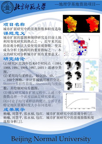
地理学基地项目结题

地理学基地项目_杨曦_展板

小明同学的帮助下,结题报告的最后一个任务——展板总算是做好了,自己还算满意,贴出来庆祝一下。

如何阅读一篇科研文献(英文)

很多大学生也许和我现在一样需要阅读许多文献,在查找文献的时候,很多人会发现其实在领域内领先的文献都是英文的,所以阅读英文文献就成了一个问题。因为对待文献的时候你不仅要面临长句难句这种一般阅读困难,或者是会遇到专业名词,更主要的是,你还需要理解作者在说什么。
偶然的机会在网上看到这篇文章How to Read a Scientific Research Paper–a four-step guide for students and for faculty,和大家分享。

International Conference in GIS and Health—探讨地理信息系统(GIS)与公共卫生的联系

今年六月底,在香港大学将举办关于GIS和公共卫生的联系的国际会议,主要的议题是Geospatial Research and Application Frontiers in Environmental and Public Health Systems.

其实在100多年前的英国,就已经有使用地理信息系统解决公共卫生问题的案例了,当时英国伦敦传染病肆虐,一位医生在地图上标出所有患者的位置,发现在水井旁的居民很少染病,于是医生提出要使用清洁的水,有效的控制了传染病的传播。

随着SARS和禽流感的进一步流行,GIS在分析和控制这些传染病方面将会起到更大的作用。大会主要讨论问题有:

* Epidemiological catastrophe

* Environmental modeling and disease occurrences

* Population and public health disease surveillance

* Health care planning

* Methodological issues of GIS in health

* Technical perspectives of GIS in health

* Local case study

* Future trends